Beryl, which formed in the Atlantic Ocean at the end of June, quickly strengthened to become a multiple-record-breaking hurricane that left a trail of death and disaster across multiple countries. Over the course of two weeks, it became strong enough to devastate two islands in the Caribbean, move heavy concrete underwater barricades, cause millions to lose power and bring deadly flooding to parts of the U.S., from Texas up through New England.
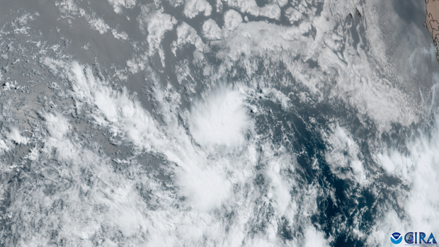
New video from the Cooperative Institute for Research in the Atmosphere, known as CIRA, shows its treacherous journey — from the moment it became a tropical depression on June 28 to its remnants spawning tornadoes and heavy rain in the Northeast this week.
Here’s a timeline of what happened:
Cooperative Institute for Research in the Atmosphere at Colorado State University and the National Oceanic and Atmospheric Administration (CSU/CIRA & NOAA)
June 22
According to NASA’s Global Precipitation Measurement, the storm that would become Beryl first formed from a low pressure tropical wave off the Atlantic coast of Africa on June 22. Such waves, known as African Easterly Waves, often help provide a base for tropical storms and hurricanes that develop in the Atlantic and Caribbean.
It appeared in an area off Africa’s coast that usually doesn’t become active until August or September. Above-average sea surface temperatures — a known fuel for hurricanes — prompted the early formation. NASA said temperatures were running between 1 and 2.5 degrees Celsius above the norm.
June 28
Six days later, the National Hurricane Center’s observations confirmed that the system had further developed, designating it as Tropical Depression Two. It strengthened within a few hours to become a tropical storm with 40 mph winds, and was given the name Beryl.
June 29
Beryl officially became a Category 1 hurricane and quickly underwent rapid intensification, a process in which a cyclone dramatically strengthened in a short amount of time.
June 30
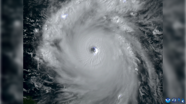
Sunday, June 30 marked a historic turn for Beryl. On this day, it reached major hurricane status — a Category 3 on the Saffir-Simpson wind scale, with wind speeds of 115 mph. Hours after hitting that milestone, it strengthened even further to become the earliest Category 4 hurricane on record in the Atlantic, with 130 mph winds.
Cooperative Institute for Research in the Atmosphere at Colorado State University and the National Oceanic and Atmospheric Administration (CSU/CIRA & NOAA)
July 1
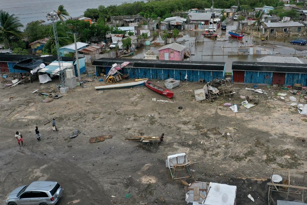
Maintaining its Category 4 status, Hurricane Beryl directly hit the 13-square-mile Grenada island of Carriacou. Grenada’s Prime Minister Dickon Mitchell said the storm had left “almost Armageddon-like” destruction in its wake, with “almost total damage or destruction of all buildings.”
“Complete and total destruction of the natural environment,” Michell said. “There is literally no vegetation left anywhere on the island of Carriacou.”
Nearby Union Island, which belongs to St. Vincent and the Grenadines, saw 90% of its homes severely damaged or destroyed from the hurricane, its Prime Minister Ralph Gonsalves said, calling Union “a field of devastation.”
At least three people were killed in Grenada and at least three more in St. Vincent and the Grenadines.
July 2
Beryl reaches its peak intensity — 165 mph winds. At this point, it was the highest category of hurricane, a Cat 5, which is designated for storms with wind speeds of at least 157 mph. Storms of this wind strength will cause “catastrophic damage,” according to NOAA, and can leave the majority of an area “uninhabitable for weeks or months.”
July 3
Beryl’s Category 5 status was short-lived, though it remained incredibly powerful. On this day, Beryl brushed by Jamaica as a Category 4 hurricane with sustained winds of 140 mph. The eye of the storm didn’t make landfall, but the hurricane caused significant damage.
Many in Jamaica still remain without power and water as of July 12, according to the Jamaica Observer. At least three people were reported killed.
Getty Images
July 4
Still a major hurricane, but somewhat weakened, Beryl brushed by the Cayman Islands as a Category 3. It continued to weaken to a Category 2 storm with 110 mph winds, but it once again hit above-normal water temperatures and saw wind conditions that gave it additional strength to regain major hurricane status.
July 5
With wind speeds just 1 mph shy of Category 3 status, Beryl made landfall once again on Mexico’s Yucatan Peninsula, near Tulum. By the time it reached the Gulf of Mexico later in the day, it had considerably weakened to a tropical storm.
July 7
After sporadic storm activity, Beryl had reorganized itself and was starting to strengthen once again as it started on a track toward Texas.
July 8
In its final landfall, Beryl hit Texas as a Category 1 hurricane with 80 mph sustained winds. It maintained that intensity over the Matagorda and Houston areas for hours, resulting in a massive power outage for more than 2.7 million people. As of midday Friday, July 12, more than 1 million people in Texas remained without power.
The storm also spawned more than 100 tornado warnings, the most ever for a single day in July, according to CBS News senior weather producer David Parkinson.
July 9 and beyond
After Beryl’s Texas landfall, it weakened into a storm system impacting a large swath of the U.S. Tornadoes continued to be a threat between Louisville, Indianapolis and Cincinnati ,while flooding impacted areas from Little Rock, Arkansas, to Waterbury, Vermont.
Beryl was a “prolific rain producer” that brought 4 inches of rain in just three hours in some areas, Parkinson said.
It’s unknown how long it will take all areas impacted by Beryl, from the Caribbean to Mexico to the U.S. — to completely recover. As of July 12, the storm’s death toll has surpassed 20.


